
In 2018 we expanded the FDL.AI from the US to Europe. Working in partnership with the European Space Agency (ESA) we hosted a research sprint at the University of Oxford. With the support of NVIDIA and the Satellite Applications Catapult, two teams of researchers tackled challenges under the mission area “Mission Control for Planet Earth”. We wanted to test the idea that it might be possible to create a virtual Mission Control Centre that would enable us to monitor, predict and be better placed to respond to threats to the planet and its inhabitants.
The research sprint was a great success, and the outputs from the teams showed that the idea of Mission Control for Planet Earth has great potential to be further developed in future.


MAPPING INFORMAL SETTLEMENTS
To use AI and Earth observation data to identify, and automate mapping of, informal settlements to enable governments and aid agencies to better monitor and support these communities.
One-third of the world’s urban population lives in informal settlements (source: World Bank, 2009 data). Yet it is not uncommon that the locations and sizes of these settlements are simply unknown. People living in these areas often have no security of residence, often lack basic services, and housing is unlikely to comply with planning, building and safety regulations.
Detecting and mapping informal settlements is of importance to a number of the United Nations Sustainable Development Goals (SDGs). This is due to that fact that it is the most socially and economically disadvantaged people who often call these informal settlements “home”.
However, data regarding informal and formal settlements is hard to come by, and if it exists at all, is often incomplete. Identifying where these settlements are is of paramount importance to both government, and non- government organisations (NGOs), such as the United Nations Children’s Fund (UNICEF), who can use this information to assist in delivering effective social and economic aid. Traditional methods of gathering this data are costly, preventing efforts to gather such information at the required scale.
Our team of researchers had just eight weeks to see if they could use the combination of Earth observation data and AI techniques to map informal settlements - no easy challenge!
Ongoing Impact
The team has presented their work at prestigious AI conferences (NeurIPS and AAAI), and it was featured by FDL Europe partner NVIDIA and GeoConnexion. They are seeking partners to continue working on the project and support its deployment.


-
-
Mapping Informal Settlements in Developing Countries using Machine Learning and Low Resolution Multi-spectral Data - DOI
AAAI/ACM Conference on AI, ethics and society
Authors: Bradley Gram-Hansen, Patrick Helber, Indhu Varatharajan, Faiza Azam, Alejandro Coca-Castro, Veronika Kopackova, Piotr BilinskiMapping Informal Settlements in Developing Countries with Multi-resolution, Multi-spectral Data - DOI
Neurips 2018
Authors: Bradley Gram-Hansen, Patrick Helber, Indhu Varatharajan, Faiza Azam, Alejandro Coca-Castro, Veronika Kopackova, Piotr BilinskiGenerating Material Maps to Map Informal Settlements - DOI
NeurIPS 2018
Authors: Bradley Gram-Hansen, Patrick Helber, Indhu Varatharajan, Faiza Azam, Alejandro Coca-Castro, Veronika Kopackova, Piotr Bilinski

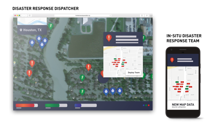
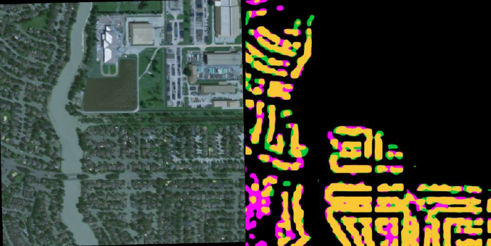
MACHINE LEARNING TO AID DISASTER RESPONSE
To use state-of-the-art AI to dramatically reduce the time and effort required to create effective disaster impact maps.
Disaster events such as earthquakes, hurricanes, and floods cause loss of human lives and create substantial economic damage. Lack of information about the level of damage immediately following these events restricts first-responder efforts, hinders efficient response coordination by authorities, and delays can lead to additional loss of life.
The minutes, hours and days after a natural disaster are critical and insights into the scale and type of damage can help to inform the rescue effort. The faster that this can be achieved, the faster an informed response can be put together.
Ongoing Impact
The team have presented a poster and a paper at leading AI conferences NeurIPS and AAAI. They are currently working on spin-off projects stemming from their initial work. UNICEF has expressed an interest in deploying this work in real-world situations and the team is currently working on a feasibility study to see how this could be implemented.
-
Rapid Computer Vision-Aided Disaster Response via Fusion of Multiresolution, Multisensor, and Multitemporal Satellite Imagery
NeurIPS 2018
Authors: Tim G. J. Rudner, Marc Rußwurm, Jakub Fil, Ramona Pelich, Benjamin Bischke, Veronika Kopacková, Piotr Bilinski.Multi3Net: Segmenting Flooded Buildings via Fusion of Multiresolution, Multisensor, and Multitemporal Satellite Imagery - DOI
33d AAAI Conference on Artificial Intelligence
Authors: Tim G. J. Rudner, Marc Rußwurm, Jakub Fil, Ramona Pelich, Benjamin Bischke, Veronika Kopackova, Piotr Bilinski
HOW ELSE CAN I GET INVOLVED WITH FDL Europe?
Follow us on Twitter, LinkedIn and sign up for our newsletter
If you have any questions, please do send us an email